


Focus on Earthquakes app for iPhone and iPad
Developer: Tasa Graphic Arts, Inc.
First release : 12 Mar 2012
App size: 127.87 Mb
Focus on Earthquakes provides a comprehensive description of the causes and consequences of earthquakes. In addition to the text, this new-media textbook provides illustrations, photos, narrated animations and slide shows that aid in understanding the concepts presented. Interactive quizzes and review questions are provided throughout the text to test and reinforce ones understanding.
Apps For Homeschooling rated this app 5 out of 5 apples and said "...this app is sure to answer all your child’s questions about earthquakes..."
Childrens Technology Review rated it 4.7 out of 5 and said "This is a great way to bring the outside world -- quite literally -- into your classroom."
AppCraver.com scored it 5 out of 5 and said "...beautifully designed illustrations, photos and narrated animations that help present challenging concepts in a visually brilliant way..."
Topics covered include:
- the causes of earthquakes
- the relationship between earthquakes and faults
- earthquake waves
- seismometers and earthquake detection
- locating the source of an earthquake
- measuring the size of earthquakes
- earthquake damage and large historical quakes
- tsunamis, firestorms, landslides, and liquefaction
- earthquake prediction
- plus an in-depth discussion of the relationship between earthquakes and plate tectonics
Written by respected professors and Earth science authors Ed Tarbuck and Fred Lutgens and illustrated by Dennis Tasa, this app will be of interest to anyone who wants to learn about earthquakes. For schools, this interactive app can be used as an in-class tool or for independent study.
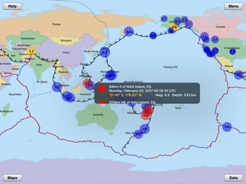
In addition to the text, the EARTHQUAKE TRACKER feature provides a visual display of recent earthquake activity on a 3D globe or on a 2D flat map. The combination of a physiographic surface map, overlays of tectonic plate boundaries, recent volcanic activity, and recent earthquakes dramatically illustrates the relationship between tectonic plates and earthquakes. This highly interactive feature gives the user control over the display of quake magnitudes, depths, and times as well as historical quakes. Map types and boundaries can be changed dynamically to aid the visualization of these relationships. The information on each earthquake (from USGS data) can be displayed by tapping on a quake circle.
This app provides a complete tool for the study and understanding of earthquakes.